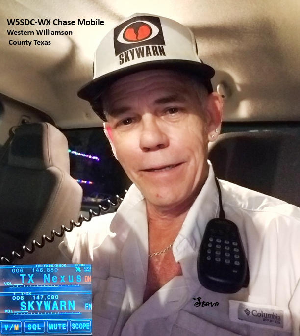
EF-2
Mason Creek Subdivision
Leander, Texas
Thursday, March 16, 2000 around 4 pm
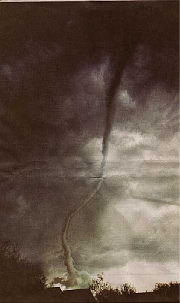
Peter Yang photographed the funnel cloud from Blockhouse Creek (about 3
miles away) as I stood directly underneath looking straight up into the
bottom of the funnel shortly before it made contact with the ground. The funnel's base was rotating very slowly and
drifting slowly northeast. Once the funnel became a tornado (contact with the ground) it followed a south southwestern track through Mason Creek. I was
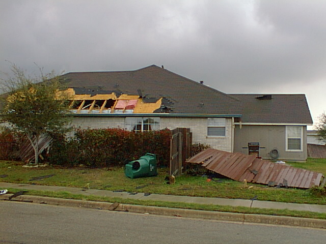
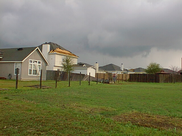
standing on my front porch when the tornado reached our house. Using the
Enhanced Fujita Scale table below as a guide, it appears that we
received EF-0 to EF-1 level damage. The houses behind ours sustained worse
damage closer to EF-2 levels and also a storage building was blown into a neighbor's backyard. |
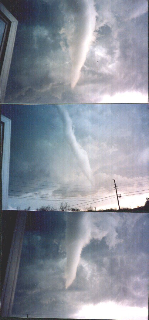
Photos from Glass Street in Leander as the EF-0 tornado struck near the old downtown police station prior to hitting Mason Creek as a low level EF-2
Photos courtesy of Jim Kinter Jr. K5KTF
Enhanced Fujita Tornado Scale
| EF-Scale Number |
Intensity Phrase | Wind Speed |
Type of Damage Done |
|---|
| EF-0 | Minor tornado |
65-85 mph | Some damage to chimneys; breaks branches off trees; pushes over shallow-rooted trees; damages sign boards. |
|---|
| EF-1 | Moderate tornado |
86-110 mph | The lower limit is the beginning of hurricane wind speed; peels surface off roofs; mobile homes pushed off foundations or overturned; moving autos pushed off the roads; attached garages may be destroyed. |
|---|
| EF-2 | Significant tornado |
111-135 mph | Considerable damage. Roofs torn off frame houses; mobile homes demolished; boxcars pushed over; large trees snapped or uprooted; light object missiles generated.
|
|---|
| EF-3 | Severe tornado |
136-165 mph | Roof and some walls torn off well constructed houses; trains overturned; most trees in forest uprooted |
|---|
| EF-4 | Devastating tornado |
166-200 mph | Well-constructed houses leveled; structures with weak foundations blown off some distance; cars thrown and large missiles generated. |
|---|
| EF-5 | Incredible tornado |
>200 mph | Strong frame houses lifted off foundations and carried considerable distances to disintegrate; automobile sized missiles fly through the air in excess of 100 meters; trees debarked; steel re-inforced concrete structures badly damaged. |
|---|
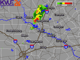
Radar showing the line of thunderstorms that produced this tornado
Mason Creek is located at the bottom of the G in close proximity to the Travis county line.
(captured by Leander Fire Dept)
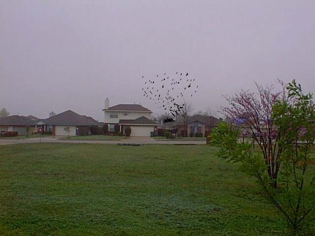
This is a simulated ground zero view I had of the tornado at the moment just before I retreated to cover just milliseconds before it hit Mike and Kelly Bouldin's home. Ronald Taylor's roof is the simulated debris here, and this image depicts the picture in my mind that I shall never forget. Notice that except for the swirling vortex of roofing materials, the tornado was otherwise invisible.
Pieces of roof debris fluttered slowly to the ground after the tornadic wind instantly uplifted them an (estimated) four residential stories into the air . |
The Bouldin house on Greening Way showing classic low level EF-2 tornado damage. This is where I began my house to house search for injured neighbors. I found a very shaken but uninjured Bouldin family inside. |
The side of Ron Taylor's home showing the area very near touchdown.
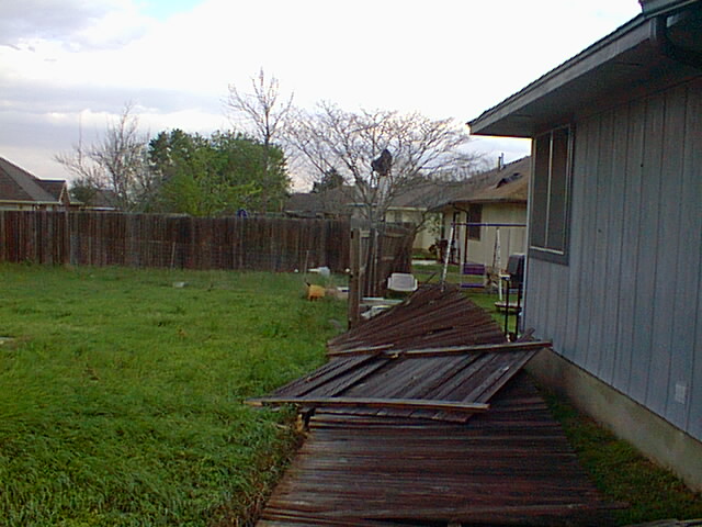
Front of our house showing EF-1 levels of roof and fence damage.
Our Border Collie, Shiloh, escaped the tornado through the opening
in the fence and hid under a bed for hours. She was presumed lost
until my wife Diane noticed a tail wagging under the edge of the bed some 3
1/2 hours later. Fortunately, the tornadic wind blew and held both
front doors open for her escape back into shelter. |
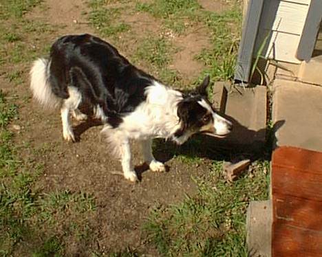
RIP Shiloh, gone but not forgotten
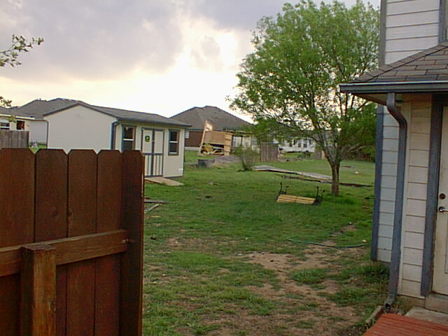
Path of the twister through our backyard. Amazingly, our storage
building suffered no damage other than minor paint scuffs from
flying debris. The storage building in the yard directly behind ours,
was tipped and rolled into their neighbor's back yard. |
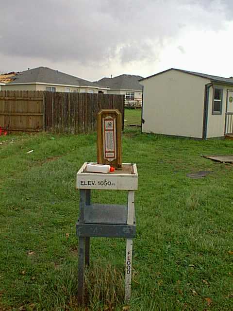
The top was ripped off of my weather instrument shelter leaving the thermometer and charcoal fluid untouched. The late Lou Withrow was the MIC at the Austin National Weather Service office when I received my Severe Weather Spotter Training. Lou was my Skywarn instructor and helped me design and build the instrument shelter. Lou provided the plans from his NWS office filing cabinet. The flood gauge was his idea. |
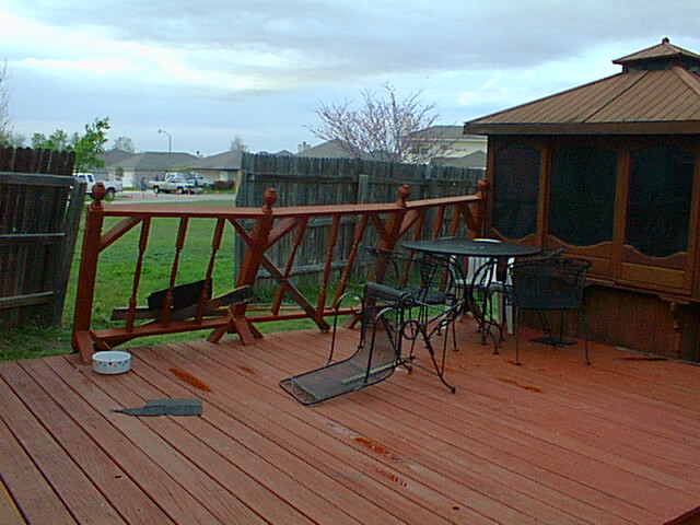
A shot showing the general direction that the twister came from and the damaged deck railing that I had built just one month before the storm. |
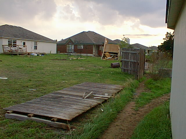
View of the tornado's path from behind our storage building showing our back neighbor's shed that was tipped over and rolled into their neighbor's backyard. |
Only posts remain in a 125 foot fence as Caroline and John Olenoski survey their EF-2 category roof damage. Only three fence sections could be accounted for. The rest were swept away. |
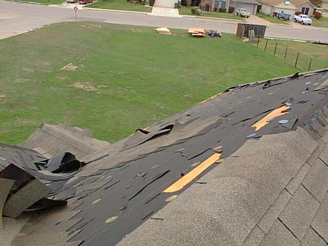
Largest section of our EF-1 roof damage. Building materials donated by Cashway Lumber appear at the edge of Mason Creek Blvd. |
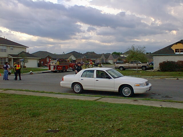
Leander Police seal off damaged areas from onlookers and potential looters as firefighters search for gas leaks and cut power. |
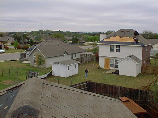
Caroline looks on as repairs commence on her roof.
 ®
®
Skywarn® and the Skywarn®logo are registered trademarks of the National Oceanic and Atmospheric Administration. Used with permission.
Skywarn® is a nationwide network of trained severe weather spotters. The National Weather Service does not sponsor spotters directly or fund their activities, but they do provide the training for spotters.
Modern Doppler radar is excellent for tracking and forecasting severe weather events, however; it cannot equal or replace trained eyes in the field.
Severe weather observation near storms can be risky, therefore; fame and glory is not what the Skywarn program is about. Safety is always first. We are driven solely by a desire to relay accurate realtime information to the weather service in an effort to save lives and property via the earliest public warnings possible.
E-Mail message I received from the National Weather Service on March 22, 2000:
Stephen,
Thank you for your message. Although I only had time for a quick scan at your
web page, it looked great. I've bookmarked it for when I can take my time and
really enjoy reviewing it. I agree that the damage in your subdivision was F2
in places, with most of the damage in the F0 or F1 range.
Thank you for your account in this tornado outbreak - it will be very helpful
when I write our Storm Data Report.
Larry Eblen |
Official Storm Data Report
Larry Eblen-MIC National Weather Service
In memory of
Lou Withrow
1936-1995

As mentioned earlier, Lou took the time and helped me design and build the instrument shelter for my first outdoor home weather station. I attended Mr. Withrow's Skywarn® severe weather spotter training class at the fire station in Granite Shoals, Texas and was assigned as Wilco Spotter WI-1 since I had no amateur radio callsign at the time.
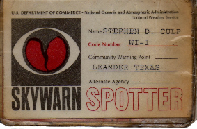
Back in those days, he
was the meteorologist-in-charge at the national weather service office in Austin located at the old Robert Mueller Airport on Manor Road. He typed up my spotter ID card above. |